[00:00:02] Welcome everyone to the hunkerdownguide.com podcast on Hurricane preparedness. And I'm your host, Jamie Robe. And we're going to do these every Thursday. Just a brief look ahead in the tropics, especially at the beginning of the season here where there's not a lot of activity.
[00:00:22] But what I'm going to do is we are going to, to the hunker down guide.com website which you're welcome to come in and use these resources.
[00:00:35] I've got this tropical weather center down here and I look at the, for the hurricane tracking room.
[00:00:41] Okay. And what I've done is collected all of the maps and satellite images and all the things that I look at all the time and have it all, I have the computer update and pull these things from all the official sites and links back to the, all the sites that they come from.
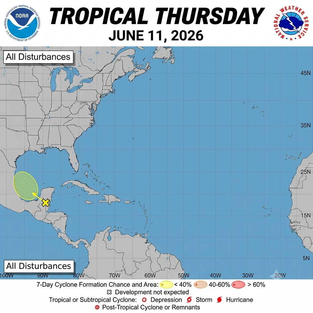
[00:00:59] So you know, I, I invite you again to take a look at this. You can see there's a table of contents over here and that, you know, will follow through here. So you can do this yourself anytime you want. I update these things constantly and they're usually, you know, from the official sources. It depends. Some things are updated almost in real time and other things, you know, hourly or daily things like that, depending what they are. Obviously longer range forecasts are less, you know, they're updated less frequently. But still, if we go to our, say, our two day tropical weather outlook map, surprisingly we can see something in here. There's actually a 10% chance of Cyclone development over here by the Yucatan Peninsula.
[00:01:51] And if we, you know, take a look at the seven day graphic from the hurricane center, you can see that there is a blob, you know, a little X and a blob. And when, if you click on that you get, you know, zoom in and you can see that this is a disturbed area and it's a pretty low percentage. They're saying 10% chance, you know, go of it moving to the northwest and they're saying that that's over the next seven days this could happen.
[00:02:34] And, but they're saying it's likely that it's going to move over Mexico and go inland probably just as a bunch of storms from Saturday to Sunday time frame this week. So nothing is threatening the continental US at this point on these long range forecasts. Now one of the things I'll, I'll do is we'll go over to the actual site and we can switch to the Pacific view and you can see there's, there's been activity. Remember last Thursday on the, on the long range things, they were showing a lot of activity down in this eastern Pacific region.
[00:03:20] But you pop over to the central Pacific, here's Hawaii, there's, there's nothing expected in the next seven days.
[00:03:27] So again, you know, we're looking at something that's most likely going to move into the eastern part of Mexico here and, you know, not disturb the U.S. but again, when you're looking at this stuff, you can go down and take a look at, you know, what they write. Exactly.
[00:03:46] You know, I will obviously be checking this every single day during the hurricane season and just wanted to let you know what's going on. Now just for fun, since there's no immediate threat there of anything to us, let's take a look at some of the other things we've got on here, the maps. This is interesting to look at because if you look at sea surface anomalies, you can see that the bluer and up to the red or the scale. And we don't really have any big anomalies going right now in our area.
[00:04:27] But if you look at the sea surface temperatures, you can see where they've been predicting this activity over in the, remember, there's the El Nino effect that is building in the Pacific, but you can see where it's hotter water in that Pacific area and it's relatively still cool.
[00:04:49] Now the scale, if you look at the reddest areas, Say between 30 and 32 Celsius, which is about 86 to 90 degrees Fahrenheit.
[00:05:03] The waters in the Gulf and around all around here are, you know, 20, 24 to 28 degrees Celsius, which is 75 to 82 Fahrenheit.
[00:05:17] So you kind of have to learn some of these other units of measure over time. This one showing there's not much heat potential. Remember, heat is the engine for these hurricanes and tropical storms.
[00:05:34] So another map that I like to look at is the precipitation potential. Now down in this area there's going to be obviously this, whatever the storms are building, these thunderstorms are going to be moving into Mexico where pretty normal in the rest of the southeast US Anyway. Looks like some storms hitting the central part of the country.
[00:05:59] And another thing, I like to look at just the satellite imagery. So if we look at the general, you know, satellites that have been taking imagery, you can see, you know, it's pretty calm right now and there are these storms building up like near the Yucatan again, that's probably going to move off to the, the northwest and not bother us.
[00:06:25] So I hope that, you know, this helps a little bit and can kind of educate you on what kinds of resources there are to look at.
[00:06:35] Obviously, you can track a lot of this on your local news, weather and the Weather Channel and those kinds of places. But I like to look at this stuff myself.
[00:06:46] And I'll be back every Thursday. And until we start getting more activity, then we might go every other day or every day even.
[00:06:54] But anyway, I hope that, you know, you can help use this time to prepare for this season.
[00:07:04] And if we can help you
[email protected] just, you know, visit us there and you can join us and look at these maps yourself and read the other materials about hurricane preparation and hope you have a great week.